Teesta grapples with massive siltation after GLOF
New report shows alterations, which raise concerns about future flood risks & stability of surrounding areas
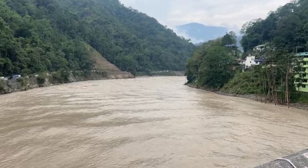
 Gangtok, June 9: A recent study examining the Teesta River’s morphology following the October 2023 Glacial Lake Outburst Flood (GLOF) event has revealed significant siltation and changes in the river’s longitudinal and lateral profiles. These alterations raise concerns about future flood risks and the stability of surrounding areas, necessitating continuous monitoring and careful consideration of mitigation strategies.
The study by the Ministry of Jal Shakti , which surveyed a 120km stretch from Zema to Teesta Bazar, revealed substantial sediment deposition throughout the riverbed, with the most dramatic changes observed in the lower reaches. Key findings include significant lateral profile changes, increased silt content, varied impact along the river’s length, and lateral deposition.
Key observations
Lateral profile changes: Significant variations in riverbed elevation and channel width, indicating substantial sediment deposition at various sites.
- Sankalang: A bed level rise of approximately 10 meters, suggesting heavy sediment deposition.
- Makha: A 2-meter rise in bed level and lateral expansion, indicating sediment bar formation.
- Singtam: Development of braid bars and alternate channel paths due to excessive sediment load.
- Mamring Bridge: Vertical aggradation of approximately 2 m, increasing the risk of overbank flow.
- Khanitar: Bed level rising up to 2 m, leading to potential backwater effects.
- Melli: The most extreme aggradation, with a bed level rise of nearly 14 m, drastically reduces channel capacity and increases flood hazards.
- Teesta Bazar: A 6-7 m rise in the riverbed and channel widening, indicating sediment accumulation at the downstream end.
Longitudinal profile changes: The river’s slope and bed elevation along its course were also examined. The upper reaches from Zema to Chungthang, characterised by a steep gradient, experienced channel deepening and scouring. In contrast, the lower gradient zone from Chungthang to Teesta Bazar witnessed significant aggradation, particularly in areas like Melli and Rangpo, where reduced flow velocity caused sediments to settle.
Key findings
The GLOF event has significantly altered the Teesta River’s natural regime, leading to altered channel morphology, increased silt content, varied impact along the river’s length, and lateral deposition.
Recommendations:
The study emphasises that any interventions aimed at increasing channel conveyance require detailed scientific backing. While acknowledging the need for potential river training and bank protection at locations threatening habitations, the report recommends that thorough geological, morphological and hydrological surveys precede such measures.
Continuous monitoring of the Teesta River’s morphology is crucial to understanding the long-term effects of the GLOF event and informing effective mitigation strategies for managing flood risks and protecting vulnerable communities.
Further studies are underway to determine the best course of action and ensure the long-term stability of the Teesta River Basin.
The Teesta River in Sikkim has experienced significant erosion and deposition due to the GLOF event, which is a natural process in a river system. However, dredging throughout the river reach is not considered a techno-economically viable solution.
Instead, based on mathematical model studies, selective interventions in the form of anti-erosion/pro-siltation measures, such as bank revetment and submerged gabion studs, should be adopted. Selective and need-based dredging can be attempted at important infrastructures, and catchment area treatment should be undertaken to manage sedimentation.
Gates of the control structure should be maintained, and non-structural measures such as Flood Plain Zoning regulation should be adopted. The above recommendations must be implemented coordinated and adaptive, guided by periodic morphological reassessments and stakeholder consultations.
While this report provides a detailed assessment of the morphological impacts of the GLOF event in the Teesta River, several limitations and assumptions must be acknowledged, including the lack of Pre-GLOF Field Survey Data, Remote Sensing Constraints, Ground Truthing Not Conducted, Limited Cross-Sectional Coverage, Event Attribution, and Assumption of Sediment Homogeneity.